When you’re looking at Lower East Side apartments or thinking about buying a condo here, the vibe is usually the first thing that grabs you. It’s historic, it’s gritty, and it’s energetic. But once the excitement settles, the practical questions start creeping in. How do I get to work? Can I actually keep a car here? Is the subway a hike?
The good news is that the Lower East Side (LES) is quietly one of the most connected pockets of Manhattan. Because it sits right at the diverse intersection of the Williamsburg Bridge, the East River, and the downtown grid, you have a unique mix of transit options. You aren't just relying on one train line; you have ferries, express buses, and bike paths all woven into the neighborhood fabric.
Here is the real scoop on getting around the LES in 2026.
Connectivity in the Lower East Side
If you are thinking about living in Lower East Side neighborhoods, you should know that this area acts as a transit bridge between Manhattan and Brooklyn. It’s not just about getting uptown; it’s about having the flexibility to shoot across the river to Williamsburg for dinner or hop on the FDR Drive to escape the city for the weekend.
The neighborhood is dense, meaning you rarely have to walk more than a few blocks to find a subway entrance, a bus stop, or a Citi Bike dock. While some parts of the city feel isolated from the main arteries, the LES feels plugged into everything. Whether you work in Midtown, the Financial District, or DUMBO, you have a direct line to get there.
Subway Service: The Neighborhood Hubs
The subway is the lifeblood of the area, and service here is anchored by a few major hubs that cover different corners of the neighborhood.
Delancey St-Essex St Station: This is the beating heart of transit in the LES. Located right at the foot of the Williamsburg Bridge, this station connects the F, M, J, and Z lines. It’s a massive advantage for residents because it offers redundancy. If the F train is running slow, you can often jump on the J or Z to get to the Financial District in minutes. The J/Z lines are also your golden ticket to North Brooklyn if you want to skip the bridge traffic.
Grand St Station: Heading a bit south and west toward Little Italy, you hit the Grand St station. This serves the B and D lines. These are your express options. The D train is fantastic for shooting up to Midtown quickly or heading deep into Brooklyn. It’s a high-traffic station, but the speed is worth it.
East Broadway Station: Tucked away in the southeastern pocket of the neighborhood, the East Broadway stop serves the F line. This station tends to be a bit quieter and serves the residents living closer to the Two Bridges area. It’s a straight shot to Midtown or under the river to DUMBO.
You also have the 2nd Ave (F) and Bowery (J/Z) stations sitting right on the borders, expanding your options depending on which street you live on.
Bus Routes: Crosstown and Uptown Access
Subways are great for north-south travel, but if you need to go crosstown—say, to the West Village or Chelsea—the bus is often your best bet. The LES has excellent Select Bus Service (SBS) routes.
If you aren't familiar with SBS, these are the blue buses that run in dedicated lanes. You pay at the sidewalk kiosk before you board, which speeds up the whole process significantly.
• M14A-SBS: This route loops down towards Grand Street and the FDR. It is a lifeline for residents in the far eastern part of the neighborhood (like near the co-ops on Grand St) who might be a 15-minute walk from the subway. It cuts straight across town to the Meatpacking District.
• M14D-SBS: Similar to the A, but this one terminates further north near Delancey and the FDR. It’s perfect for getting from the Alphabet City/LES border over to Union Square and Chelsea.
• M15 & M15-SBS: These run along 1st Avenue (northbound) and 2nd Avenue (southbound). They form a transit spine that can get you up to the United Nations or East Harlem, or down to the Staten Island Ferry terminal.
There is also the M9, a local route that connects Kips Bay to City Hall, winding through the LES streets. It’s slower, but helpful for short local hops.
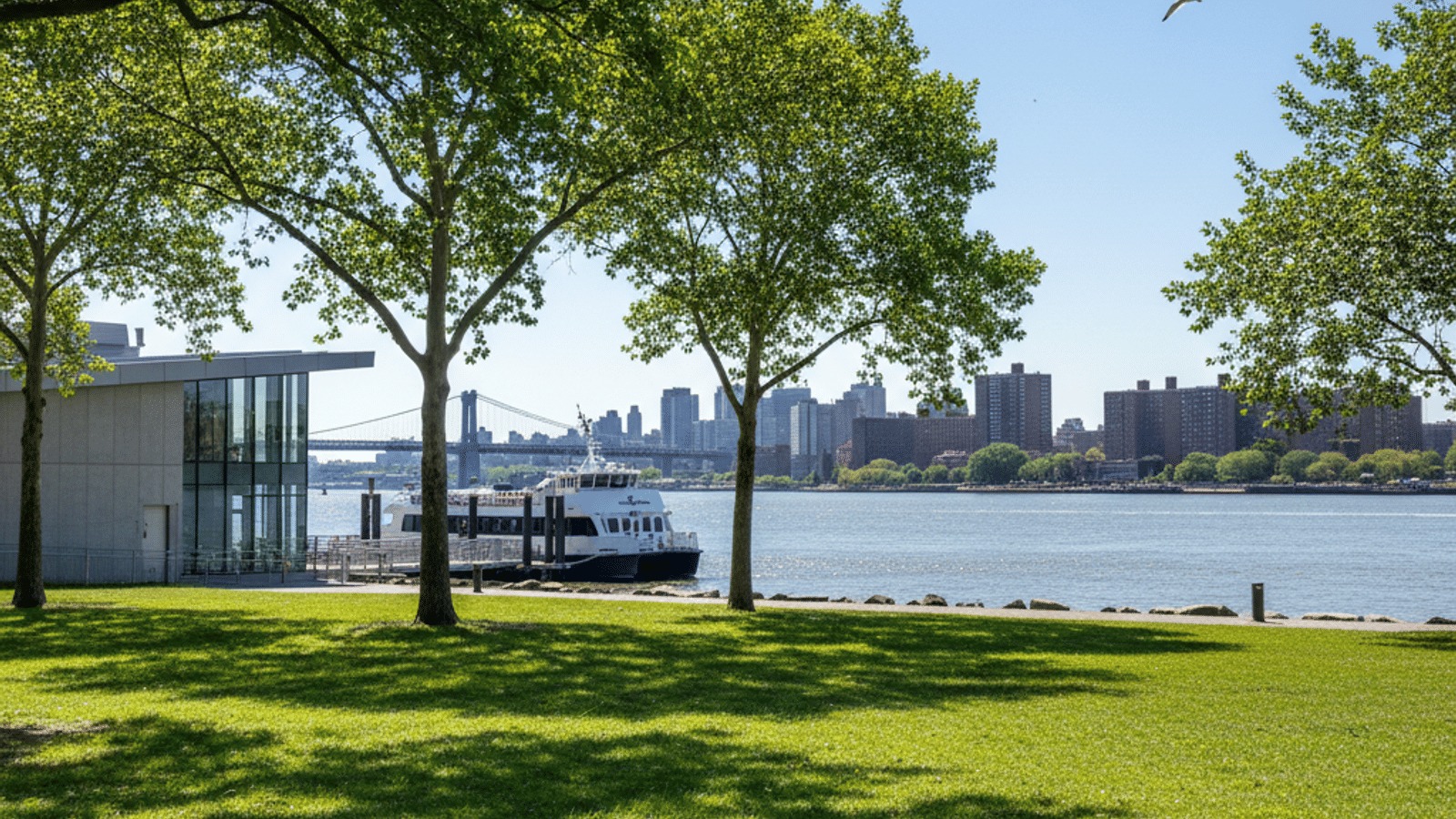
The NYC Ferry at Corlears Hook
One of the most overlooked perks of the area is the NYC Ferry stop at Corlears Hook. Located inside Corlears Hook Park on the far east side, this is a game-changer for anyone working near Wall Street who wants a stress-free commute.
The South Brooklyn (SB) route stops here. In about 10 minutes, you can be at Pier 11/Wall St. It’s fast, the views are incredible, and you get fresh air instead of subway heat. It also connects you to DUMBO and other parts of South Brooklyn.
If you live in one of the buildings along the East River waterfront, this might actually be your closest and most pleasant transit option. The fare is roughly the same as a subway ride—currently $4.00 for a single trip—so it’s affordable enough for daily use.
Cycling and Citi Bike Availability
If you prefer two wheels, the Lower East Side is arguably a biker’s paradise. The terrain is generally flat, and the infrastructure has improved massively over the last decade.
You will find a high density of Citi Bike docking stations, so finding a bike is rarely an issue, even during rush hour. The crown jewel for cyclists here is the Williamsburg Bridge bike path. The entrance is at Clinton St and Delancey St. It’s a direct, protected lane that drops you into Brooklyn. It’s a tough climb, but the ride down is a breeze.
For local riding, you have protected bike lanes along Allen Street (in the malls) and excellent paths along the East River waterfront. It’s very easy to commute by bike from here to almost anywhere in lower Manhattan without fighting heavy car traffic.
Walkability and Neighborhood Layout
When we talk about a Lower East Side neighborhood guide, we have to talk about walking. This area is a "Walker's Paradise" with a grid system that makes navigation simple.
Everything you need is usually within a five-minute radius. You have the Essex Market for groceries and food, endless nightlife options on Ludlow and Orchard Streets, and plenty of parks. The neighborhood has also embraced pedestrian plazas. Streets like Broome and parts of the Lower East Side often have sections closed off to cars, creating more open space for people to walk, sit, and gather.
Driving and Parking Situation
Let’s be real for a second: keeping a car here is not for the faint of heart.
Street parking in the LES is notoriously difficult. The Alternate Side Parking (ASP) rules are strict, and competition for spots is fierce. You will see people sitting in their cars for 30 minutes waiting for the street sweeper to pass.
If you need a car—maybe for work or frequent weekend trips—budgeting for a garage is the smartest move. There are several options, including the large modern garage at Essex Crossing. Prices vary, but generally, you can expect to pay anywhere from $350 to $600 per month in 2026.
The upside to driving? You have immediate access to the FDR Drive. While getting across town can be slow due to congestion on Delancey Street, jumping on the highway to head north towards Westchester or south to the Battery Tunnel is super quick.
Estimated Commute Times
Here is a quick cheat sheet for what your morning commute might look like from the heart of the LES
• To Midtown (34th/42nd St): Expect a 20–30 minute ride. The F train or D express are your best bets here.
• To Financial District (Wall St): Very fast. Roughly 15–20 minutes on the J/Z train, or just a 10-minute ferry ride if you are near the water.
• To Williamsburg: You can be there in 10–15 minutes. It’s just one stop on the J/M/Z over the bridge, or a nice bike ride.
• To Union Square: This is a quick hop. You can take the L train from the 1st Ave stop (just north of the LES border) or grab the M14 bus. It usually takes about 15 minutes.
Accessibility Notes
For those moving with strollers, heavy luggage, or mobility needs, it’s important to check the station details.
• Delancey-Essex Station is ADA accessible and has elevators, which makes it the primary entry point for many.
• Older stations, like East Broadway, have historically lacked elevators, so you should always check the current MTA status before planning your route.
• Buses are a reliable alternative; the entire fleet is wheelchair accessible with kneeling features and ramps.
Frequently Asked Questions
What is the best subway station for the Lower East Side?
The Delancey St-Essex St station is generally considered the main hub. It offers the most options (F, M, J, Z lines), connects directly to the Williamsburg Bridge, and features elevator access, making it the most versatile starting point for most commuters.
Is it difficult to park a car in the Lower East Side?
Yes, street parking is very challenging due to density and alternate side parking rules. Most residents who own cars opt for monthly garages, which can cost between $350 and $600 per month, though having quick access to the FDR Drive is a major perk for drivers.
How long does it take to commute from the Lower East Side to Midtown?
It typically takes about 20 to 30 minutes to reach Midtown Manhattan. The F train and the D express train are your fastest options for getting to 34th Street or Rockefeller Center.
Does the NYC Ferry stop in the Lower East Side?
Yes, the NYC Ferry stops at Corlears Hook Park on the far east side of the neighborhood. It services the South Brooklyn route, providing a scenic and fast 10-minute connection to Wall Street/Pier 11 and DUMBO.